
The ministère des Ressources naturelles et des Forêts has decided to amend the ban on open fires in or in the vicinity of a forest. This decision, taken in collaboration with the Société de protection des forêts contre le feu (SOPFEU), therefore results in the modification of the area targeted by the ban on open fires in or in the vicinity of a forest. Given the evolution of the weather, the measure is modified as of Saturday, July 8, 8 a.m.
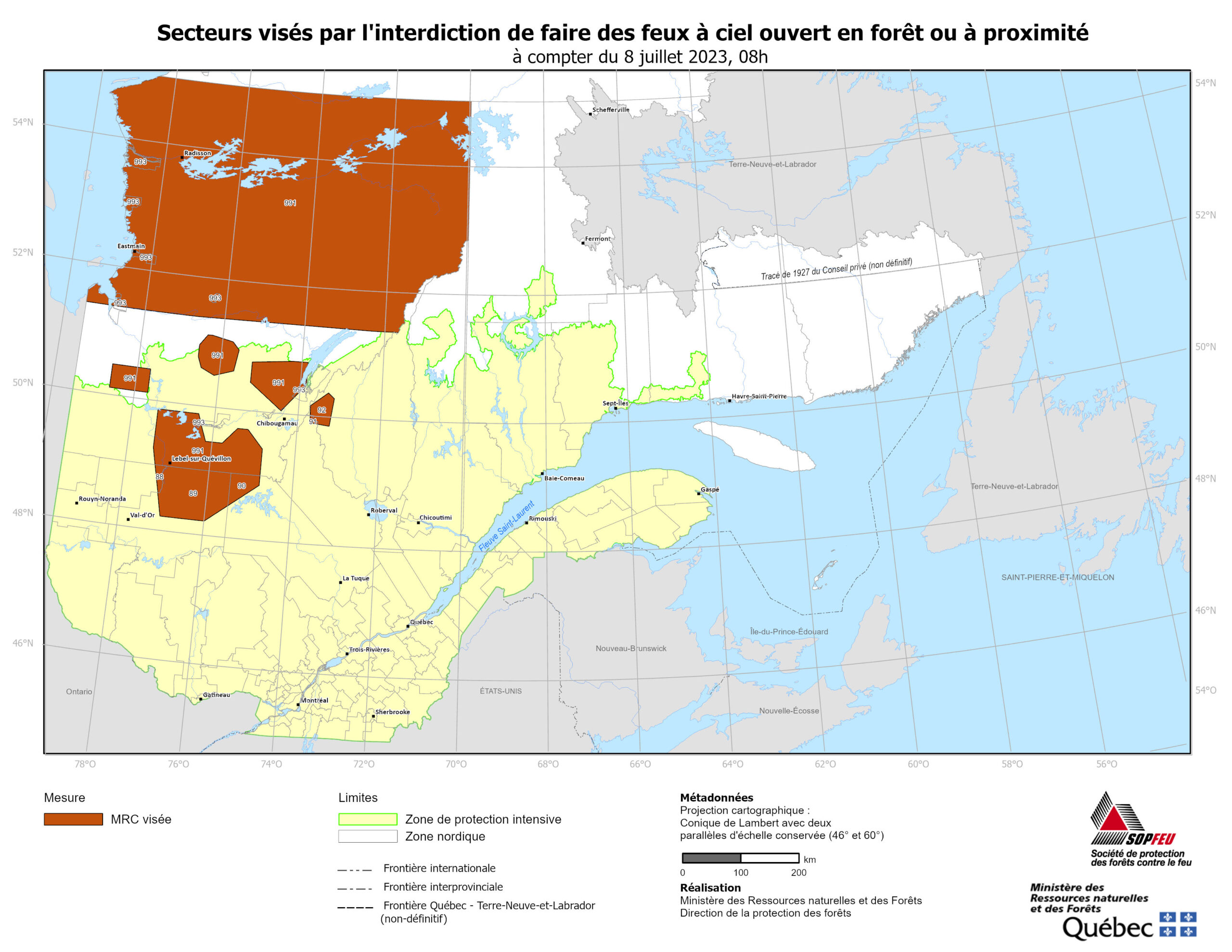
The areas affected by this measure are the following RCMs and territories:
NORD-DU-QUÉBEC: Jamésie (991) for its portion north of latitude 51°22’, as well as for its portions bounded by the following coordinates:
78° 39’ W 50° 28’ N
77° 43’ W 50° 28’ N
77° 43’ W 50° 06’ N
78° 39’ W 50° 06’ N
AND
77° 25’ W 49° 52’ N
76° 26’ W 49° 52’ N
76° 12’ W 49° 27’ N
75° 48’ W 49° 27’ N
75° 28’ W 49° 42’ N
75° 13’ W 49° 42’ N
74° 50’ W 49° 25’ N
74° 50’ W 49° 00’ N
77° 19’ W 49° 00’ N
77° 25’ W 49° 16’ N
AND
76° 25’ W 51° 06’ N
75° 47’ W 51° 02’ N
75° 37’ W 50° 55’ N
75° 42’ W 50° 35’ N
76° 10’ W 50° 29’ N
76° 30’ W 50° 35’ N
76° 36’ W 50° 45’ N
76° 36’ W 50° 56’ N
AND
75° 16’ W 50° 45’ N
73° 54’ W 50° 49’ N
73° 54’ W 50° 28’ N
74° 28’ W 50° 02’ N
75° 16’ W 50° 26’ N
AND
78° 22’ W 54° 51’ N
71° 00’ W 54° 51’ N
71° 00’ W 53° 59’ N
72° 52’ W 52° 20’ N
76° 48’ W 52° 20’ N
76° 48’ W 54° 10’ N
78° 22’ W 54° 10’ N
AND
Eeyou Istchee (993)
Waswanipi for its portion west of the line bounded by the following coordinates:
76° 23’ W 49° 46’ N
76° 20’ W 49° 41’ N
Mistissini for its portion north-west of the following coordinates:
73° 54’ W 50° 34’ N
73° 54’ W 50° 28’ N
74° 10’ W 50° 15’ N
Chisasibi, Eastmain, Nemiscau, Waskaganish for its portion north of latitude 51°22’, Wemindji) (993).
SAGUENAY–LAC-SAINT-JEAN: Le Domaine-du-Roy (91) for its portion north-east of the following coordinates:
73° 45’ W 50° 00’ N
73° 45’ W 49° 53’ N
73° 34’ W 49° 52’ N
Maria-Chapdelaine (92) for its portion within the following coordinates:
73° 46’ W 50° 09’ N
73° 21’ W 50° 22’ N
73° 12’ W 50° 17’ N
73° 17’ W 49° 51’ N
73° 45’ W 49° 53’ N
ABITIBI-TÉMISCAMINGUE: Abitibi (88) for its portion east of the line bounded by the following points:
77° 19’ W 49° 00’ N
77° 11’ W 48° 34’ N
La Vallée-de-l’Or (89) for its portion northeast of the following coordinates:
77° 11’ W 48° 34’ N
77° 04’ W 48° 13’ N
76° 02’ W 48° 13’ N
75° 31’ W 48° 29’ N
MAURICIE: La Tuque (90) for its portion within the following coordinates:
75° 31’ W 49° 00’ N
74° 50’ W 49° 00’ N
74° 50’ W 48° 51’ N
75° 31’ W 48° 29’ N
Consult the map of the territory concerned
There are currently 66 fires in activity in Québec. Since the start of the protection season, 500 forest fires have affected 1 496 857 hectares. The average for the last 10 years at this time of the year is 295 fires for an area of 14 984 hectares.
Everyone must collaborate to make sure that the ban on open fires in the forest is respected. This measure is intended to limit the risk of forest fires. Pursuant to section 239 of the Sustainable Forest Management Act (chapter A-18.1), any person who contravenes an order prohibiting open fires in or in the vicinity of a forest or any other action taken by the Minister is liable, in addition to the payment of the costs, to a fine.
SIÈGE SOCIAL (médias nationaux)
Stéphane Caron
418 871-3341
RÉGION EST
Isabelle Gariépy
418 295-2300
RÉGION CENTRE
Josée Poitras
418 275-6400
RÉGION OUEST
Melanie Morin
819 449-4271